Placeholder Content Image

Bank's worrying forecast for when housing prices will plummet

<p>According to the lastest NAB forecast, property prices in Australia are expected to take a turn for the worst this year, before plunging by 11 percent by 2023. </p><p>After the Reserve Bank flagged that interest rates could be on the rise at some point this year, NAB drastically revised their initial outlook on property prices over the next two years.</p><p>In NAB's <a href="https://business.nab.com.au/nab-quarterly-australian-residential-property-survey-q4-2021-51029/" target="_blank" rel="noopener">Residential Property Survey</a> for the latest quarter, they have warned, “With our view on rate hikes coming forward, we now expect the turning point in property prices to occur in the second half of 2022.”</p><p>As a result, property is set to rise in value by just three percent this year, compared to a 22 percent boom in 2021 which had not been seen since the mid-1980s. </p><p>While 11 percent seems like a huge drop, the author of the report has reassured that it is a controlled drop. </p><p>“We see this as a relatively orderly decline,” the report noted. </p><p>“It is important to remember this correction comes after a very sharp run up in prices over the last year.”</p><p>As a result of the rising interest rate expectations, NAB brought forward its predictions of a correction. </p><p>“In terms of forecasts, we have brought forward the timing of the correction we expect in house prices to late-2022 as affordability constraints begin to bite and rising mortgage rates place downward pressure on prices,” the bank said. </p><p>“This would offset gains seen in early-2022, so that overall, prices end the year roughly flat. We see this trend continuing through 2023, ending the year around 10 per cent lower.”</p><p>Sydney and Melbourne will be hit hardest, dropping by nearly 12 percent each next year.</p><p>Hobart will face the lowest drop for 2023 at only 4 percent. </p><p>The combined capital city average was forecast to be a 9.4 percent decrease next year.</p><p>NAB have warned that interest rates could be on the rise as early as November this year.</p><p><em>Image credits: Getty Images</em></p><div class="media image" style="color: #000000;font-style: normal;font-weight: normal;letter-spacing: normal;text-align: start;text-indent: 0px;text-transform: none;text-decoration: none;flex-direction: column;align-items: center;width: 705.3308715820312px;margin-bottom: 32px"> </div>

Money & Banking

Placeholder Content Image

World economy in 2022: the big factors to watch closely

<p>Will 2022 be the year where the world economy recovers from the pandemic? That’s the big question on everyone’s lips as the festive break comes to an end.</p> <p>One complicating factor is that most of the latest major forecasts were published in the weeks before the <a rel="noopener" href="https://www.who.int/news/item/26-11-2021-classification-of-omicron-(b.1.1.529)-sars-cov-2-variant-of-concern" target="_blank">omicron variant</a> swept the world. At that time, the mood was that recovery was indeed around the corner, with the IMF projecting <a rel="noopener" href="https://www.imf.org/en/Publications/WEO/Issues/2021/10/12/world-economic-outlook-october-2021" target="_blank">4.9% growth</a> in 2022 and the OECD <a rel="noopener" href="https://www.oecd.org/newsroom/oecd-economic-outlook-sees-recovery-continuing-but-warns-of-growing-imbalances-and-risks.htm" target="_blank">projecting 4.5%</a>. These numbers are lower than the circa 5% to 6% global growth expected to have been achieved in 2021, but that represents the inevitable rebound from reopening after the pandemic lows of 2020.</p> <p>So what difference will omicron make to the state of the economy? We already know that it had an effect in the run-up to Christmas, with for example <a rel="noopener" href="https://www.theguardian.com/business/live/2021/dec/23/omicron-hits-uk-economy-growth-car-production-market-optimism-energy-crisis-business-live?filterKeyEvents=false&amp;page=with:block-61c46e4c8f08efd5f0de270a#block-61c46e4c8f08efd5f0de270a" target="_blank">UK hospitality</a> taking a hit as people stayed away from restaurants. For the coming months, the combination of raised restrictions, cautious consumers and people taking time off sick is likely to take its toll.</p> <p>Yet the fact that the new variant seems milder than originally feared is likely to mean that restrictions are lifted more quickly and that the economic effect is more moderate than it might have been. <a rel="noopener" href="https://www.reuters.com/world/middle-east/israel-admit-some-foreigners-with-presumed-covid-immunity-jan-9-2022-01-03/" target="_blank">Israel</a> and <a rel="noopener" href="https://www.aljazeera.com/economy/2022/1/3/australia-pushes-on-with-reopening-amid-milder-impact-of-omicron" target="_blank">Australia</a>, for example, are already loosening restrictions despite high case numbers. At the same time, however, until the west tackles very low <a rel="noopener" href="https://ourworldindata.org/covid-vaccinations?country=OWID_WRL" target="_blank">vaccination rates</a> in some parts of the world, don’t be surprised if another new variant brings further damage to both public health and the world economy.</p> <p>As things stand, the UK thinktank the Centre for Economics and Business Research (CEBR) published a more recent <a rel="noopener" href="https://www.bloomberg.com/news/articles/2021-12-26/world-economy-now-set-to-surpass-100-trillion-in-2022" target="_blank">2022 forecast</a> just before Christmas. It predicted that global growth would reach 4% this year, and that the total world economy would hit a new all-time high of US$100 trillion (£74 trillion).</p> <p><strong>The inflation question</strong></p> <p>One other big unknown is inflation. In 2021 we saw a sudden and sharp surge in inflation resulting from the restoration of global economic activity and bottlenecks in the <a rel="noopener" href="https://obr.uk/box/the-economic-effects-of-supply-bottlenecks/" target="_blank">global supply chain</a>. There has been <a rel="noopener" href="https://theconversation.com/inflation-why-its-temporary-and-raising-interest-rates-will-do-more-harm-than-good-172329" target="_blank">much debate</a> about whether this inflation will prove temporary, and central banks have been coming under pressure to ensure it doesn’t spiral.</p> <p>So far, the European Central Bank, Federal Reserve and Bank of Japan have all abstained from raising interest rates from their very low levels. The Bank of England, on the other hand, followed the <a rel="noopener" href="https://www.ft.com/content/ca15ce59-ca72-497c-bf7a-c1482d972f01" target="_blank">IMF’s advice</a> and <a rel="noopener" href="https://www.bankofengland.co.uk/monetary-policy-summary-and-minutes/2021/december-2021" target="_blank">raised rates</a> from 0.1% to 0.25% in December. This is too little to curb inflation or do any good besides increase the cost of borrowing for firms and to raise <a rel="noopener" href="https://www.bbc.com/news/business-59140059" target="_blank">mortgage payments</a> for households. That said, the <a rel="noopener" href="https://www.reuters.com/markets/europe/sterling-nears-2-year-high-vs-euro-rate-rise-bets-2022-01-04/" target="_blank">markets are betting</a> that more UK rate rises will follow, and that <a rel="noopener" href="https://www.cnbc.com/2022/01/03/markets-and-the-economy-brace-as-the-feds-first-hike-could-come-in-two-months.html" target="_blank">the Fed</a> will also start raising rates in the spring.</p> <p>Yet the more important question regarding inflation is what happens to quantitative easing (QE). This is the policy of increasing the money supply that has seen the major central banks <a rel="noopener" href="https://www.atlanticcouncil.org/global-qe-tracker/" target="_blank">buying some</a> US$25 trillion in government bonds and other financial assets in recent years, including about US$9 trillion on the back of COVID.</p> <p>Both the Fed and ECB are still operating QE and adding assets to their balance sheets every month. The Fed is <a rel="noopener" href="https://www.businessinsider.com/personal-finance/fed-tapering?r=US&amp;IR=T" target="_blank">currently tapering</a> the rate of these purchases with a view to stopping them in March, having recently announced that it would bring forward the end date from June. <a rel="noopener" href="https://www.ft.com/content/03a30484-b265-4a88-a861-de1784305d40" target="_blank">The ECB</a> has also said it will scale back QE, but is committed to continuing for the time being.</p> <p>Of course, the real question is what these central banks do in practice. Ending QE and raising interest rates will undoubtedly hamper the recovery – the <a rel="noopener" href="https://cebr.com/reports/city-am-uk-to-remain-one-of-the-top-six-global-economies-post-covid-says-cebr-report/" target="_blank">CEBR forecast</a>, for example, assumes that it will see bond, stock and property markets falling by 10% to 25% in 2022. It will be interesting to see whether the prospect of such upheaval forces the Fed and Bank of England to get more dovish again – particularly when you factor in the continued uncertainty around COVID.</p> <p><strong>Politics and global trade</strong></p> <p>The trade war between the US and China looks likely to continue in 2022. The “<a rel="noopener" href="https://www.piie.com/research/piie-charts/us-china-phase-one-tracker-chinas-purchases-us-goods" target="_blank">phase 1</a>” deal between the two nations, in which China had agreed to increase its purchases of certain US goods and services by a combined US$200 billion over 2020 and 2021 has missed its target <a rel="noopener" href="https://www.piie.com/research/piie-charts/us-china-phase-one-tracker-chinas-purchases-us-goods" target="_blank">by about 40%</a> (as at the end of November).</p> <p>The deal has now expired, and the <a rel="noopener" href="https://www.globaltimes.cn/page/202201/1243977.shtml" target="_blank">big question</a> for international trade in 2022 is whether there will be a <a rel="noopener" href="https://www.ced.org/solutions-briefs/the-china-trade-challenge-phase-ii" target="_blank">new “phase 2” deal</a>. It is hard to feel particularly optimistic here: Donald Trump may have long since left office, but US strategy on China remains <a rel="noopener" href="https://www.project-syndicate.org/commentary/biden-losing-china-strategy-protectionism-industrial-policy-by-anne-o-krueger-2021-09?utm_source=Project%20Syndicate%20Newsletter&amp;utm_campaign=bf7c015f95-sunday_newsletter_12_26_2021&amp;utm_medium=email&amp;utm_term=0_73bad5b7d8-bf7c015f95-105568073&amp;mc_cid=bf7c015f95&amp;mc_eid=14a09c8529&amp;barrier=accesspaylog" target="_blank">distinctly Trumpian</a>, with no notable concessions having been offered to the Chinese under Joe Biden.</p> <p>Elsewhere, western tensions with Russia over Ukraine and further escalation of economic sanctions against Putin may have economic consequences for the global economy – not least because of Europe’s dependency on Russian gas. The more engagement that we see on both fronts in the coming months, the better it will be for growth.</p> <p>Whatever happens politically, it is clear that Asia will be very important for growth prospects in 2022. Major economies such as <a rel="noopener" href="https://www.bloomberg.com/news/articles/2021-12-22/u-k-economy-closer-to-pre-pandemic-levels-despite-3q-downgrade?sref=Hjm5biAW" target="_blank">the UK</a>, <a rel="noopener" href="https://tradingeconomics.com/japan/gdp" target="_blank">Japan</a> and the <a rel="noopener" href="https://tradingeconomics.com/euro-area/gdp" target="_blank">eurozone</a> were all still smaller than before the pandemic as recently as the third quarter of 2021, the latest data available. The only major developed economy that has already recovered its losses and regained its pre-COVID size is <a rel="noopener" href="https://www.brookings.edu/blog/up-front/2021/12/08/a-most-unusual-recovery-how-the-us-rebound-from-covid-differs-from-rest-of-g7/" target="_blank">the United States</a>.</p> <p><strong>Economic growth by country since 2015</strong></p> <p><a href="https://images.theconversation.com/files/439333/original/file-20220104-18500-zchaq3.png?ixlib=rb-1.1.0&amp;q=45&amp;auto=format&amp;w=1000&amp;fit=clip"><img src="https://images.theconversation.com/files/439333/original/file-20220104-18500-zchaq3.png?ixlib=rb-1.1.0&amp;q=45&amp;auto=format&amp;w=754&amp;fit=clip" alt="" /></a> <span class="caption"></span> <em><span class="attribution"><span class="source">OECD data</span></span></em></p> <p>On the other hand, China has <a rel="noopener" href="https://www.worldometers.info/coronavirus/country/china/" target="_blank">managed the pandemic</a> well – albeit with strict control measures – and its economy has achieved strong growth since the second quarter of 2020. It has been <a rel="noopener" href="https://theconversation.com/chinas-problem-with-property-the-domino-effect-of-evergrandes-huge-debts-168601" target="_blank">struggling with</a> a heavily over-indebted property market, but appears to have handled these problems <a rel="noopener" href="https://www.wsj.com/articles/china-evergrande-says-construction-has-resumed-at-vast-majority-of-its-projects-11640602229" target="_blank">relatively smoothly</a>. Though the jury is out on the extent to which <a rel="noopener" href="https://edition.cnn.com/2021/12/15/economy/china-omicron-economy-intl-hnk/index.html" target="_blank">China’s debt problems</a> will be a drag in 2022, some such as Morgan Stanley <a rel="noopener" href="https://www.cnbc.com/2022/01/03/morgan-stanley-on-chinas-gdp-economy-in-2022.html" target="_blank">argue that</a> strong exports, accommodative monetary and fiscal policies, relief for real estate sector and a slightly more relaxed approach to carbon reduction point to a decent performance.</p> <p>As for India, whose economy has seen double dips during the pandemic, it is showing a strong positive trend with <a rel="noopener" href="https://www.imf.org/en/Publications/WEO/Issues/2021/10/12/world-economic-outlook-october-2021" target="_blank">8.5% expected growth</a> in the year ahead. I therefore suspect that emerging Asia will shoulder global growth in 2022, and the world’s <a rel="noopener" href="https://onlinelibrary.wiley.com/doi/10.1111/j.1758-5899.2010.00066.x" target="_blank">economic centre of gravity</a> will continue to shift eastwards at an accelerated pace.<!-- Below is The Conversation's page counter tag. Please DO NOT REMOVE. --><img style="border: none !important; box-shadow: none !important; margin: 0 !important; max-height: 1px !important; max-width: 1px !important; min-height: 1px !important; min-width: 1px !important; opacity: 0 !important; outline: none !important; padding: 0 !important; text-shadow: none !important;" src="https://counter.theconversation.com/content/174350/count.gif?distributor=republish-lightbox-basic" alt="The Conversation" width="1" height="1" /><!-- End of code. If you don't see any code above, please get new code from the Advanced tab after you click the republish button. The page counter does not collect any personal data. More info: https://theconversation.com/republishing-guidelines --></p> <p><em><a rel="noopener" href="https://theconversation.com/profiles/muhammad-ali-nasir-1244347" target="_blank">Muhammad Ali Nasir</a>, Associate Professor in Economics and Finance, <a rel="noopener" href="https://theconversation.com/institutions/university-of-huddersfield-1226" target="_blank">University of Huddersfield</a></em></p> <p><em>This article is republished from <a rel="noopener" href="https://theconversation.com" target="_blank">The Conversation</a> under a Creative Commons license. Read the <a rel="noopener" href="https://theconversation.com/world-economy-in-2022-the-big-factors-to-watch-closely-174350" target="_blank">original article</a>.</em></p> <p><em>Image: Getty Images</em></p>

Money & Banking

Placeholder Content Image

Why weather forecasts could become more challenging during the coronavirus storm

<p>The COVID-19 pandemic has disrupted several sectors and meteorology is no exception. The quality and quantity of the observational data that feed into weather forecasting models could well be affected by the pandemic, according to the <a href="https://public.wmo.int/en/media/press-release/wmo-concerned-about-impact-of-covid-19-observing-system">World Meteorological Organization (WMO)</a>.</p> <p>Knowing the state of the atmosphere is essential for good weather forecasting. In addition to announcing rain or sunshine, weather forecasts allow us to better prepare for risks and other weather hazards such as <a href="https://www.theglobeandmail.com/canada/article-communities-across-canada-prepare-for-doubled-crises-of-flooding-in-a/">spring flooding</a> and hurricanes.</p> <p>The pandemic has curtailed a number of these observations in a variety of ways. But scientists around the world are finding ways to fill some of those gaps.</p> <p><strong>International collaboration</strong></p> <p>The <a href="https://public.wmo.int/en/programmes/global-observing-system">WMO Global Observing System</a> provides observations of the atmosphere, such as wind speed, and the ocean surface, namely sea surface temperature. The system comes from the close collaboration between national and international agencies that provide measurements from different observing instruments.</p> <p style="text-align: center;"><img style="display: block; margin-left: auto; margin-right: auto;" src="https://images.theconversation.com/files/330858/original/file-20200427-145566-1ccwtmw.jpg?ixlib=rb-1.1.0&amp;q=45&amp;auto=format&amp;w=754&amp;fit=clip" alt="" /> <span class="caption">The World Meteorological Organization’s (WMO) Global Observing System is composed of a large number of <em>in situ</em> and satellite observing systems.</span> <span class="attribution"><span class="source">(World Meteorological Organization)</span></span></p> 
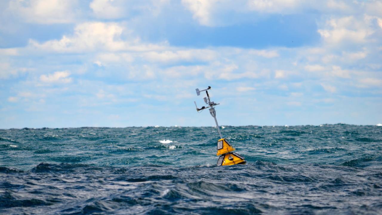
<p>The <a href="https://public.wmo.int/en/our-mandate/what-we-do/observations">WMO Global Observing System</a> relies on observations taken on land, in the air, on the ocean and from space. More than 10,000 surface-based stations, 1,000 weather balloon stations, 3,000 commercial aircraft, 7,000 ships, 100 moored buoys, 1,000 drifting buoys, 30 meteorological satellites and 200 research satellites gather information about the Earth.</p> <p>The frequency and spatial distribution of these measurements vary enormously depending on the type of observation. For example, a surface weather station can collect precipitation measurements every five minutes, while the <a href="https://cloudsat.atmos.colostate.edu/education/faq">CloudSat</a> satellite, dedicated to global cloud observation, takes measurements covering the same geographical area every 16 days.</p> <p><strong>How forecasts are made</strong></p> <p>Atmospheric models are a set of equations that describe the changing state of the atmosphere. They require information about the initial state of the atmosphere and the Earth’s surface (land and ocean) in order to provide weather forecasts.</p> <p>Unfortunately, observational data alone are not sufficient to provide a complete picture of the state of the atmosphere because they are distributed irregularly over space and time, and sometimes contain errors.</p> <p>This is where a technique known as “<a href="https://research.reading.ac.uk/met-darc/aboutus/what-is-data-assimilation/">data assimilation</a>” comes into play. It involves combining observational data with data obtained from an atmospheric model to get the best estimate of the state of the atmosphere. In other words, one starts from a weather forecast made with the model and corrects it with the observational data.</p> <p>The result of the data assimilation is a coherent complete image of the atmosphere and the Earth’s surface at a given time. Once the initial state of the atmosphere and Earth’s surface is known, an atmospheric model can be applied to predict its evolution.</p> <p><strong>The impact of the pandemic</strong></p> <p>The COVID-19 pandemic has caused a <a href="https://public.wmo.int/en/media/press-release/wmo-concerned-about-impact-of-covid-19-observing-system">decrease in observations</a> made by commercial aircraft, due to the decrease in air traffic. In Europe, for example, there has been a <a href="https://www.eurocontrol.int/Economics/DailyTrafficVariation-States.html">90 per cent</a> decline in the daily number of flights.</p> <p>There has also been a drop in manual observations at surface weather stations in several developing countries, which have not switched to fully automated measurements. In the long term, other components of the observing system could be negatively affected if maintenance, repair and replenishment work cannot be done.</p> <p>Each type of observation has a different impact on the quality of forecasts. <a href="https://www.ecmwf.int/en/about/media-centre/news/2020/drop-aircraft-observations-could-have-impact-weather-forecasts">Studies</a> conducted by the European Centre for Medium-Range Weather Forecasts (ECMWF) have shown that in the absence of aircraft meteorological data, the quality of short-term wind and temperature forecasts at cruising altitude decreases by 15 per cent, which can affect the prediction of the jet stream and, consequently, forecasts of winter storms and heat waves. The quality of near-surface forecasts also decreases, but not as much.</p> <p>Ironically, the importance of aircraft observation data was highlighted in mid-February 2020 at an ECMWF <a href="https://www.ecmwf.int/en/learning/workshops/workshop-aircraft-weather-observations-and-their-use">workshop on the state of aircraft observations</a>. Fortunately, the impact of satellite observations on forecast quality is greater than that of aircraft meteorological data.</p> <p><strong>Mobilizing scientists</strong></p> <p>The scientific community is trying to ease the impact of the decrease in observational data collected by aircraft. As a result, European national meteorological services are <a href="https://www.ecmwf.int/en/newsletter/163/editorial/ecmwf-and-covid-19">launching more weather balloons</a>.</p> <p>Observations from recently launched satellites can also help to fill the gap left by declining observations. This is the case of the <a href="https://www.esa.int/Applications/Observing_the_Earth/Aeolus/COVID-19_Aeolus_and_weather_forecasts">European Space Agency’s Aeolus satellite</a>, which provides wind data at different altitudes.</p> <p>The declining quality of weather forecasts adds to the many challenges posed by the pandemic. With the <a href="https://tropical.colostate.edu/media/sites/111/2020/04/2020-04.pdf">Atlantic hurricane season</a> expected to be more active than usual, it is even more important to correctly forecast the trajectory and intensity of hurricanes. Indeed, for <a href="https://www.undrr.org/news/covid-19-risks-complicating-caribbean-hurricane-season">Caribbean countries</a>, where the peak of COVID-19 cases is expected just before the start of the hurricane season, the pandemic is a major obstacle in preparing for this meteorological hazard.<!-- Below is The Conversation's page counter tag. Please DO NOT REMOVE. --><img style="border: none !important; box-shadow: none !important; margin: 0 !important; max-height: 1px !important; max-width: 1px !important; min-height: 1px !important; min-width: 1px !important; opacity: 0 !important; outline: none !important; padding: 0 !important; text-shadow: none !important;" src="https://counter.theconversation.com/content/137585/count.gif?distributor=republish-lightbox-basic" alt="The Conversation" width="1" height="1" /><em><!-- End of code. If you don't see any code above, please get new code from the Advanced tab after you click the republish button. The page counter does not collect any personal data. More info: https://theconversation.com/republishing-guidelines --></em></p> <p><em><a href="https://theconversation.com/profiles/marta-moreno-ibanez-819679">Marta Moreno Ibáñez</a>, PhD candidate in Earth and atmospheric sciences, <a href="https://theconversation.com/institutions/universite-du-quebec-a-montreal-uqam-2410">Université du Québec à Montréal (UQAM)</a></em></p> <p><em>This article is republished from <a href="https://theconversation.com">The Conversation</a> under a Creative Commons license. Read the <a href="https://theconversation.com/weather-forecasts-could-become-more-challenging-during-the-coronavirus-storm-137585">original article</a>.</em></p>

International Travel

Placeholder Content Image

“As bad as it gets”: Catastrophic conditions forecast for NSW and QLD bushfires

<p>With three people dying and 200 homes and sheds being lost to bushfires over the weekend in NSW and QLD, experts have warned that the worst is still yet to come.</p> <p>Firefighters are on the front-line battling blazes in both states, with residents in parts of Western Australia also being on high alert with “extreme fire danger” forecasted for the South Interior.</p> <p>There are also catastrophic conditions predicted for the Greater Sydney and the Greater Hunter areas tomorrow.</p> <p>Anthony Clark from the RFS has said that the situation would be “as bad as it gets”.</p> <p>“There’s a lot of hard work ahead of us, but the simple message is we’re not going to get on top of those fires before these really bad conditions hit on Tuesday,” Mr Clark said to<span> </span><em><a rel="noopener" href="https://www.news.com.au/technology/environment/nsw-and-qld-bushfires-worst-may-still-be-yet-to-come-with-catastrophic-conditions-forecast/news-story/705539262c371c80f4e00c4ab32b1979" target="_blank">news.com.au.</a></em></p> <blockquote class="twitter-tweet" data-lang="en-gb"> <p dir="ltr">It's been a weekend of destruction and devastation across NSW in the midst of a bushfire emergency but this morning we're being warned the worst is yet to come. <a href="https://twitter.com/hashtag/9News?src=hash&amp;ref_src=twsrc%5Etfw">#9News</a> <a href="https://t.co/uiWr7IYpKR">pic.twitter.com/uiWr7IYpKR</a></p> — Nine News Sydney (@9NewsSyd) <a href="https://twitter.com/9NewsSyd/status/1193622471968116736?ref_src=twsrc%5Etfw">10 November 2019</a></blockquote> <p>Meteorologist Ben Domensino has said that a mass of hot air is moving to the east from Western Australia.</p> <p>“It is elevating fire danger ratings in South Australia and parts of Victoria today on Monday, then on Tuesday, the threat will shift and focus into NSW and Wednesday, it pushes further north,” he said.</p> <p>“So that’s why we’re seeing these danger ratings in South Australia elevated fire danger ratings across multiple states on multiple days.</p> <p>“The drought’s been widespread and in some places record breaking.</p> <p>“We have known this has been coming for months because we’ve had this dry weather leading up to the hottest time of year.</p> <p>“Now we’re seeing the winds increasing, the temperatures increasing, which are typical of this time of year. But we don’t normally have this much fuel.</p> <p>“We are seeing all of those conditions combined to create the perfect conditions for catastrophic fire danger ratings which is the highest rating on that scale and the first time it has been issued for Sydney.”</p> <p>It was a devastating weekend, with 200 homes and sheds lost in QLD and NSW and three people passing away due to the bushfires. There are still 61 fires burning in NSW and 51 fires still burning in Queensland.</p> <p>The RFS site has warned that those with a “catastrophic” rating that “leaving early is the only option”.</p> <p>“Leave bushfire prone areas the night before or early in the day – do not just wait and see what happens,” the RFS site says. “Homes are not designed to withstand fires in catastrophic conditions so you should leave early.”</p> <ul> <li>For bushfire updates in NSW, go to the<span> </span><a rel="noopener" href="https://www.rfs.nsw.gov.au/fire-information/fires-near-me" target="_blank">NSW RFS website</a>.</li> <li>For bushfire updates in QLD, go to the<span> </span><a rel="noopener" href="https://www.ruralfire.qld.gov.au/map/Pages/default.aspx" target="_blank">QLD RFS website</a>.</li> <li>For bushfire updates in Western Australia, go to the<span> </span><a rel="noopener" href="https://www.emergency.wa.gov.au/" target="_blank">Emergency WA website</a>. <span> </span><span> </span></li> </ul>

Travel Trouble

Placeholder Content Image

Summer’s not over yet! Hot weather and heatwave warnings across Australia

<p>Summer has technically ended for Australia, but the hot weather is here to stay for at least another week.</p> <p>Much of Australia's south and south-east will feel the heat in the coming week, thanks to the “blocking high” wind on the Tasman Sea that is bringing funnel desert heat down.</p> <p>South Australia, Victoria and Tasmania could expect to swelter through a hot weekend as the Bureau of Meteorology predicted severe heatwaves until Saturday, and for longer in some areas.</p> <p>"Weather records could be broken over the next week," said Tom Saunders, meteorologist at <a rel="noopener" href="https://www.news.com.au/technology/environment/severe-heatwave-forecast-for-south-australia-victoria-and-tasmania/news-story/a1056095bec72f6889c9ae4f3004361c" target="_blank">Sky News Weather</a>.</p> <p>Melbourne is predicted to hit 37C on Friday, while Hobart could reach 37C on Saturday. Adelaide might fare worse, with the potential to hit 40C on Friday and Saturday, and 37C on Sunday.</p> <p>The South Australian State Emergency Service has released an extreme heatwave emergency warning for Adelaide and the state, encouraging people to keep cool and stay hydrated throughout the period.</p> <blockquote class="twitter-tweet" data-lang="en-gb"> <p dir="ltr">⚠ Extreme Heatwave Emergency Warning for <a href="https://twitter.com/hashtag/Adelaide?src=hash&amp;ref_src=twsrc%5Etfw">#Adelaide</a> &amp; <a href="https://twitter.com/hashtag/SouthAus?src=hash&amp;ref_src=twsrc%5Etfw">#SouthAus</a> Take action to make sure you and your family stay well during this heat event <a href="https://t.co/L7fvDg2ZpT">https://t.co/L7fvDg2ZpT</a> <a href="https://twitter.com/hashtag/BeathTheHeat?src=hash&amp;ref_src=twsrc%5Etfw">#BeathTheHeat</a> <a href="https://twitter.com/hashtag/Heatwave?src=hash&amp;ref_src=twsrc%5Etfw">#Heatwave</a> <a href="https://t.co/aFGUdVOv74">pic.twitter.com/aFGUdVOv74</a></p> — SA SES (@SA_SES) <a href="https://twitter.com/SA_SES/status/1100524317115277313?ref_src=twsrc%5Etfw">26 February 2019</a></blockquote> <p>Total Fire Bans have been placed on seven districts around South Australia that are at a "Severe" risk, including the Mount Lofty Ranges and the Lower South East.</p> <p>A Total Fire Ban has also been placed on Victoria's south-west region for today, which is also at the "Severe" level of risk.</p> <p>Canberra is expected to be in the 30s until Wednesday, while Penrith in New South Wales could get as hot as 39C next week. In the north, Darwin will hit 33C on Friday and Saturday.</p> <p>Perth remains mostly temperate, with 23C forecasted for today and an expected return to the low-30s on Sunday. However, Kalgoorlie reached 45.3C yesterday, hitting a record high for a February day in 80 years. Emergency WA has enforced Total Fire Bans for 10 regions in the state's south-east.</p> <p>How will the weather be in your city for the next week and how are you planning to stay cool? Let us know in the comments.</p>

Domestic Travel

Placeholder Content Image

Flash flood warning: The Aussie state set to get hit with one month’s rain in just 24 hours

<p>Although summer has nearly arrived, much of eastern NSW will encounter wet and windy weather on Wednesday, with the potential for flash flooding.</p> <p>On Wednesday, Sydney and Illawarra are expected to receive 100 millimetres of rain, with some localised areas forecast to receive more than 20mm.</p> <p>Bureau forecaster Olenka Duma said: “At this stage it looks like [the biggest totals will be] mostly through the Illawarra and potentially southern parts of Sydney.”</p> <p>"Certainly there will be heavy falls and local flash flooding, no doubt within that vicinity".</p> <p>The rain will be caused by a transient low-pressure system that will move across NSW on Tuesday and off shore on Wednesday.</p> <p>It is expected to shift north and then move away by Thursday.</p> <p>As well as receiving a month’s worth of rain in a day, NSW will also face lashing winds and dangerous surf conditions.</p> <p>Ms Duma told the <a href="https://www.smh.com.au"><span style="text-decoration: underline;"><strong><em>Sydney Morning Herald</em></strong></span></a> that precipitation totals will increase as the system drags warm tropical air from Queensland into NSW ahead of the rain.</p> <p>Those in Queensland can expect record-breaking November heat.</p> <p>In NSW, winds could reach potentially damaging levels on Wednesday evening as the rain recedes.</p> <p>The system is also expected to cause coastal damage along some parts of NSW.</p> <p>The showers and wind will make NSW see cooler than average days on Wednesday and Thursday, however, temperatures will pick up again by the weekend.</p> <p>Temperatures in Sydney for November have been roughly 1.5 degrees above the average for both day and night.</p> <p>Will you be hit by the burst of wild weather? Let us know in the comments below.</p>

Domestic Travel

Placeholder Content Image

Good news for drought-stricken farmers: Extreme rain about to hit

<p>A burst of rain is set to drench the east coast of Australia, bringing a month’s worth of rain in just two days.</p> <p>According to the Bureau of Meteorology, the rain will hit New South Wales on Friday as the system makes its way across Australia, with drought-stricken farmers in NSW having a 90 per cent chance of receiving rain.</p> <p>The system, which progressed across southern parts of WA, is forecast to hit South Australia before turning across to NSW and Queensland.</p> <p>Sydney is expected to have a much-needed 50mm of rainfall across the weekend.  </p> <p>Sydney has received only 1.4mm of rain in the month of August so far, with the average rainfall for this time of year being around 55mm.</p> <p>Tamworth and surrounding areas will have between a 75 and 90 per cent chance of rain, with 80mm of rain expected to fall in northern New South Wales.</p> <p>Brisbane is forecast to receive 40mm of rain and 65mm on the Gold Coast.  </p> <p>The burst of rain is also expected to hit Tasmania and southern parts of Victoria, but it is likely Melbourne will miss most of the showers.</p> <p>Sky News meteorologist Rob Sharpe told <a href="https://www.news.com.au"><strong><u>news.com.au</u></strong></a> the system will lead to a “big area of rain”.</p> <p>“A front is progressing across southern parts of WA and then as that moves into South Australia, a low pressure system developing will move up and into inland areas,” he said.</p> <p>“Moving with it is a fair but of upper cold air that will lead to thunderstorms.”</p> <p>The rain is expected to increase once the system makes it way to the east coast.</p> <p>“As we move into Friday, this system will run into moisture in the east so rain will develop along the coast and Tablelands.”</p> <p>The area of rain could stretch from the Victorian border, up the entirety of the NSW coast and finally easing north of Brisbane around Rockhampton.</p> <p>“There will big areas of rain right across eastern and central parts of NSW, southern parts of Queensland. Into Monday, that will still bring rain into Gippsland and eastern Tasmania.”</p> <p>Before the rains hit, the south east coast of Australia will battle through a chilly week. </p>

Domestic Travel

Placeholder Content Image

"It’s not far off": Woolies forecasts big checkout change

<p>Since their introduction self-serve checkouts have divided shoppers but if you think they’re going away, we’re sorry to tell you they’re here to stay.</p> <p>Supermarket giant Woolworths has even hinted at a change that could go a lot further. With fewer people paying with cash, particularly at their inner-city stores, the number of self-serve checkouts accepting cash has reduced dramatically.</p> <p>Although there are no plans to remove registers that accept cash, senior Woolies executive Steve Greentree told <strong><u><a href="https://www.news.com.au/finance/business/retail/woolworths-exec-says-day-not-far-off-when-checkouts-go-cashless/news-story/fb8f747d6e601b90d0c2fac4996c99e3">news.com.au</a></u> </strong> the supermarket’s customers are increasingly “ambivalent to cash” and the day won’t be “far off” when Woolies opens a cash-free supermarket where you can only pay by card or through your phone.</p> <p>Greentree, who is Woolworths’ Metro division managing director, told the publication: “In all of our city locations, people are just ambivalent to cash now. They just don’t use it so here (at Metro Pitt St) we have three registers that take cash and that’s it; every other self-service is card only, so it’s tap and go or Apple pay.”</p> <p>The upsides for the supermarkets to go cash-free include fitting more registers in stores. Cashless tills were also safer as they aren’t targeted to thieves. And they’re less prone to breaking down.</p> <p>“They’re just much more efficient,” Greentree said.</p> <p>A Woolworths spokeswoman said there were no plans to go cashless in stores and Greentree’s comments referred to <strong><u><a href="https://www.oversixty.com.au/finance/money-banking/total-overhaul-woolies-unveils-radically-different-new-store">Woolies’ new smaller stores</a></u></strong> and not the traditional larger supermarkets.</p> <p>But Greentree said he could see a day when Woolies had a fully cashless store: “I don’t think it’s too far off. We’ll probably always have one or two (manned checkouts) but with each store we’re taking another (cash) machine out.”</p> <p>He added that it is a requirement by law that tobacco is sold by a staff member, so that register would likely be the last cash till standing.</p> <p> </p>

Money & Banking

Placeholder Content Image

Brace yourself: Snow, hail and storms are coming

<p><span>On Thursday, winter will officially be here, and Australia is embracing the season change with below-average temperatures across the south of the country.</span></p> <p><span>Hobart will face a chilly 12C on Thursday while Melbourne will peak at 14C on the same day.</span></p> <p><span>Forecasters predict snow to fall on high ground in Tasmania and, Victoria and NSW will face thunderstorms. It may even hail in Adelaide.</span></p> <p><span>On the other side of Australia, the cities will experience relatively warm weather with Perth hitting temperatures in the low-20s throughout the week.</span></p> <p><span>As the week progresses, a low-pressure system will travel across the Great Australian Bight into South Australia, Victoria and Tasmania.</span></p> <blockquote class="twitter-tweet"> <p dir="ltr">A series of cold fronts will bring showers across southern Australia over the coming days. Showers also for the east coast due to onshore winds. Snowfalls for TAS, VIC and NSW on Tue &amp; Wed. Watch out for warnings. <a href="https://t.co/Wht32WMxqY">https://t.co/Wht32WMxqY</a> <a href="https://t.co/UR3wmxJHyC">pic.twitter.com/UR3wmxJHyC</a></p> — Bureau of Meteorology, Australia (@BOM_au) <a href="https://twitter.com/BOM_au/status/1000571144607621121?ref_src=twsrc%5Etfw">May 27, 2018</a></blockquote> <p style="text-align: center;"><span> </span></p> <p><span>“A series of cold fronts will bring showers across southern Australia over the coming days. Showers also for the east coast due to onshore winds. Snowfalls for TAS, VIC and NSW on Tue &amp; Wed. Watch out for warnings,” the Bureau of Meteorology Australia tweeted.</span></p> <p><span>Two cold fronts connected with the system will bring rain and chilly temperatures into Australia’s southeast.</span></p> <p><span>Despite the cooler temperatures this week in the south, Bureau of Meteorology climatologist Dr Linden Ashcroft said there are no major climate drivers affecting the season.</span></p> <p><span>“Conditions remain neutral across both the Indian and Pacific oceans. The Indian Ocean Dipole is inactive and there are no El Nino or La Nina patterns present," she said. </span></p> <p><span>“This lack of large-scale climate drivers means our winter is likely to be more influenced by local effects.</span></p> <p><span>“It also means for much of the country there is an equal chance of a drier or wetter winter apart from southwestern Western Australia where a drier season is likely,” Dr Ashcroft said.</span></p> <p><span>This winter, the south of Australia is expected to experience warmer than average temperatures while minimum temperatures may be cooler in Queensland.</span></p> <p><strong>When it will be coolest in your city this week</strong></p> <p><strong>Hobart</strong></p> <p><span>Hobart will experience temperatures that are usual for mid-July with Thursday dipping to just 12C.</span></p> <p><strong>Melbourne</strong></p> <p><span>Melbourne is expected to be hit with scattered showers this week and on Wednesday night there will be a low of 8C. On Thursday and Friday, the forecast is 14C.</span></p> <p><strong>Adelaide</strong></p> <p><span>On Wednesday, the temperature will sink to a low of 9C. Rain and possible hail is expected to fall this evening.</span></p> <p><strong>Perth</strong></p> <p><span>This week, temperatures will fluctuate around 19-23C. A possible storm is forecast on Thursday and on Friday, overnight temperatures will sink to 6C.</span></p> <p><strong>Darwin</strong></p> <p><span>Overnight lows this week will hit around 21C.</span></p> <p><strong>Brisbane</strong></p> <p><span>By the end of the week it will be sunny, however, nights will get cooler hitting an overnight low of 8C on Friday.</span></p> <p><strong>Sydney</strong></p> <p><span>The end of the week will see the coolest nights in Sydney with overnight lows of 9C.</span></p> <p><strong>Canberra</strong></p> <p><span>The coolest day in Canberra will be on Thursday and Friday with a high of 13C. </span></p>

Domestic Travel

Placeholder Content Image

Australia – get ready for a warm May!

<p>As we enter into May, Aussies can expect to see the unusually warm weather remain for the last month of Autumn. </p> <p>May will continue to be mild as it follows the hottest single April day ever recorded, a climate outlook for the next three months from the Bureau of Meteorology (BOM) revealed.</p> <p>However, the weather is predicted to take a turn for June and July, with the cold winter chill setting in.</p> <p>The bureau said April 9 was the warmest April day in Australia since records began, with the average across the country almost reaching 35C.</p> <p style="text-align: center;"><img width="498" height="275" src="https://oversixtydev.blob.core.windows.net/media/7817841/max-temp_498x275.jpg" alt="Max Temp"/></p> <p style="text-align: center;"><em>Image credit: Bureau of Meteorology</em></p> <p>“Autumn in the south felt more like summer,” BOM climatologist Felicity Gamble said.</p> <p>Across the nation, maximum temperatures for early April were 8C above the average for the time of year.</p> <p>In south-eastern Western Australia, South Australia, western NSW and western Victoria, maximum temperatures were 12C higher than normal.</p> <p>“The prolonged heatwave in early April was exceptional. New April temperature records were set in many parts of the country, over several days,” Ms Gamble said.</p> <p>There is a greater than 70 per cent chance of the above-average temperatures to continue throughout May.</p> <p style="text-align: center;"><img width="500" height="280" src="https://oversixtydev.blob.core.windows.net/media/7817842/may_500x280.jpg" alt="May"/></p> <p style="text-align: center;"><em>Image credit: Bureau of Meteorology</em></p> <p>In northern WA, the NT, southern Queensland and most of NSW, there is more than 80 per cent chance for temperatures to soar higher than the average in the next month. </p> <p>“But as we move into winter, there’s less chance of warmer than average temperatures,” Ms Gamble said.</p> <p>However, the exception to this is southern and eastern Victoria and Tasmania, where there is expected to be a mild winter.</p> <p>Warm sea surface temperatures around New Zealand and low air pressures over the Tasman Sea are forecast to continue, which could decrease the westerly winds that bring moisture into southern Australia.</p> <p>“Below-average rainfall is likely for parts of southwest Western Australia and western Victoria. The north is likely to be wetter than average, but it’s the start of the dry season, so it won’t be as wet as recent months,” she said.</p>

Domestic Travel

Placeholder Content Image

The weather map every Australian should see

<p>Australians are being warned to prepare for a winter freeze as creator of Brisbane Weather and East Coast Weather Facebook pages, David Taylor, predicts it to be the coldest winter on record.</p> <p>If David Taylor, who has correctly predicted major weather events in the past, is right again, then Australia could experience winter temperatures chillier than those ever recorded.</p> <p><a href="http://www.dailymail.co.uk/news/article-5466309/The-map-Australian-see.html" target="_blank"><span style="text-decoration: underline;"><em><strong>Daily Mail Australia</strong></em></span></a> compiled a map to show the lowest July temperatures ever recorded using data from the Bureau of Meteorology.</p> <p>Canberra could be facing temperatures around -8C whilst Perth could face OC.</p> <p style="text-align: center;"><img width="499" height="300" src="https://oversixtydev.blob.core.windows.net/media/7816003/1_499x300.jpg" alt="1 (96)"/></p> <p>Mr Taylor told <a href="http://www.cairnspost.com.au/news/national/only-person-to-correctly-predict-townsville-weather-event-says-cyclone-will-cross-the-coast-of-north-queensland/news-story/ce6a30e0273df954e94eb2291a90db3f" target="_blank"><strong><em><span style="text-decoration: underline;">The Cairns Pos</span><span style="text-decoration: underline;">t</span></em></strong></a> that icy conditions would impact huge areas of Australia this winter.</p> <p>“It will be slightly cooler than normal in the north but the real cold will be in the southern states and southeast Queensland,” he said.</p> <p>“I wouldn't be surprised if there is snow in places where it hasn't snowed for a long time.”</p> <p>Mr Taylor determines his weather predictions from a forecast formula focused on the changes in sunspot activity, along with Global Forecast System modelling and the European Centre for Medium-Range Weather Forecast.</p> <p>Mr Taylor claims his succesfull predictions are because he tracks sunspot activity.</p> <p>Recently, he was applauded for correctly predicting that 600mm of rain would fall in Townsville on February 28.</p> <p>He explained that weather systems were susceptible to the “butterfly effect” in which small changes have far reaching impact.</p> <p>Mr Taylor also recently predicted that a cyclone could form and cross the coast of north Queensland later this week.</p> <p>The Bureau of Meteorology has said that on Thursday that chance of a cyclone forming will increase from very low to low, as a monsoon trough is becoming more active in the Gulf of Carpentaria. </p>

Domestic Travel

Placeholder Content Image

Warning: Wild weather set to batter Australia

<p>Continued heavy rain and storms are set to batter the east coast across Queensland and parts of NSW today.</p> <p>In recent days, Queensland has endured the wild weather and forecasters are warning that there is even more to come.</p> <p>New South Wales will face heavy rainfall and strong winds in some parts of the state continued from yesterday’s weather.</p> <p>Sky News Weather meteorologist Rob Sharpe said the low pressure system that had brought the rain to Townsville last week had moved west over the weekend.</p> <p>Mr Sharpe said it was lingering in the north-west and would continue to bring more heavy downfalls.</p> <p>“Townsville saw drought-breaking rain at the end of last week seeing their Ross River Dam rise from 15 per cent to 85 per cent in just a few days,” he said.</p> <p>“The dam saw a rise of 163,000ML, which is equivalent to 65,000 Olympic swimming pools worth of water.”</p> <p>“Julia Creek has seen 127mm in 24 hours to 9 am this morning and Winton saw 102mm — its heaviest rain since the year 2000,” he said.</p> <blockquote class="twitter-tweet"> <p dir="ltr">Severe Weather Warning Update: Heavy rain has extended further north into the <a href="https://twitter.com/hashtag/GulfCountry?src=hash&amp;ref_src=twsrc%5Etfw">#GulfCountry</a> this morning. Currently there is a swath of heavy rain extending from <a href="https://twitter.com/hashtag/JuliaCreek?src=hash&amp;ref_src=twsrc%5Etfw">#JuliaCreek</a> to <a href="https://twitter.com/hashtag/DonorsHills?src=hash&amp;ref_src=twsrc%5Etfw">#DonorsHills</a>, with Julia Creek recording 108mm in 6 hours. Next update at 11am <a href="https://t.co/DjFrag9dAP">pic.twitter.com/DjFrag9dAP</a></p> — Bureau of Meteorology, Queensland (@BOM_Qld) <a href="https://twitter.com/BOM_Qld/status/970441121687097349?ref_src=twsrc%5Etfw">March 4, 2018</a></blockquote> <p>Cloncurry and Mt Isa are both experiencing the wettest March in seven years. Cloncurry has already recorded 175mm and Mt Isa saw 94mm fall.</p> <p>The downpour has caused severe flooding, with fears continued rain is only going to worsen the situation.</p> <p>Localised flooding is disrupting some bus services as flooded roads cause delays.</p> <p>“Over the weekend, Cloncurry had a major flood peak at 7.56m overnight Saturday into Sunday. It was the largest flood peak since 2009,” Mr Sharpe said.</p> <p>Forecasters have warned that the wild weather isn’t in a hurry to move on.</p> <p>“Heavy rain will continue in parts of western Queensland through the working week, before it moves into the Northern Territory by the weekend,” Mr Sharpe said.</p> <p>“The rain event won’t be as heavy as it moves into the NT as it has been in Queensland.”</p> <p>The Bureau of Meteorology also issued a warning for heavy rainfall in NSW, with the central part of the state expected to be hit the worst.</p> <blockquote class="twitter-tweet"> <p dir="ltr"><a href="https://twitter.com/hashtag/Thunderstorm?src=hash&amp;ref_src=twsrc%5Etfw">#Thunderstorm</a> outlook for today. Severe thunderstorms containing very heavy rainfall, damaging wind gusts and large hail are possible this afternoon. Keep an eye out on any warnings today at <a href="https://t.co/Kx8aI4NQbc">https://t.co/Kx8aI4NQbc</a> <a href="https://t.co/jpptlBmphZ">pic.twitter.com/jpptlBmphZ</a></p> — Bureau of Meteorology, New South Wales (@BOM_NSW) <a href="https://twitter.com/BOM_NSW/status/970438153512341505?ref_src=twsrc%5Etfw">March 4, 2018</a></blockquote> <p>Earlier this week, storms brought 49mm in just 30 minutes to Dungog in the Hunter Valley.</p> <p>Mr Sharpe said NSW could expect heavy rain, damaging winds and possible hail.</p>

Domestic Travel

Placeholder Content Image

Brace yourself for more warm days and unpleasant nights

<p>Summer has sadly come to an end, but you might not want to put away that pedestal fan just yet – according to the experts, we’re in for a warmer than usual autumn.</p> <p>Dr Andrew Watkins, senior climatologist at the Bureau of Meteorology (BOM), said summer was exceptionally warm and dry for the majority of Australia’s east coast, while the west was hit with record-breaking rainfall – and things won’t be much different this autumn, either.</p> <p>The weak La Nina that’s been wreaking havoc around the country is breaking down, but Dr Watkins said there’s still an increased chance of a wetter and warmer than average March in eastern Australia.</p> <p>“Historically, autumns following the end of weak La Nina events have been drier than average, however record-high water temperatures in the Tasman Sea may increase rainfall from any east coast lows that form later in the autumn and winter,” he told <a href="http://www.news.com.au/technology/environment/melbourne-sydney-brisbane-weather-autumn-to-be-warmer-than-expected/news-story/eef2d758ec602a43d42a164a9a6e03b6" target="_blank"><strong><span style="text-decoration: underline;">news.com.au</span></strong></a>.</p> <p>So you can expect warm days and unpleasant nights for a while longer, with BOM warning heatwaves still may hit drier parts of the country – especially central Australia. </p> <p><em>Image credit: Bureau of Meteorology.</em></p>

Domestic Travel

Placeholder Content Image

Heatwave alert: Scorching hot weather returns with a vengeance

<p>After last week’s cool spell you’d be forgiven for thinking the worst of summer is finally behind us, but forecasts suggest it’s about to return with a vengeance, with parts of the country expected to face severe heatwaves in the coming days.</p> <p>Parts of Sydney and Brisbane are expected to hit the 40°C mark, with Canberra facing temperatures of 35°C and Melbourne and Adelaide not too far off.</p> <p>“There’s been a bit of a nice reprieve from that heat but it’s coming back again particularly for the south of the country,” Sky News Weather meteorologist Rob Sharpe told <a href="http://www.news.com.au/" target="_blank"><span style="text-decoration: underline;"><em><strong>news.com.au</strong></em></span></a>.</p> <p>“In Adelaide, the heatwave is going to persist across much of the week. It won’t be quite as intense as the previous heatwave that crossed southeast Australia, but we’ll still see some pretty hot temperatures moving through,” he said.</p> <p>“In Adelaide, the long-term average for February is 28.5C but on Sunday they got to 34C and that will rise this week to the point they will have six days in a row above average.”</p> <p>But what’s driving these hot conditions?</p> <p>“The reason it will get so hot is a high pressure system is setting up in the Tasman Sea off the NSW coast. Because the winds travel anticlockwise around high pressure systems, we have north-westerly winds drawing heat from the north of the country down into the south and that’s where it will sit for a number of days,” Mr Sharpe said.</p> <p><strong>Your capital city’s forecast:</strong></p> <p><strong>Adelaide</strong></p> <p>High temperatures will peak at 39°C on Friday, with a cool change coming on the weekend. While temperatures will be high, humidity is expected to be low.</p> <p><strong>Melbourne</strong></p> <p>Temperatures will peak on Wednesday at 34°C, before steadying.</p> <p><strong>Hobart</strong></p> <p>Expect a high of 28°C on Wednesday before cooler weekend conditions.</p> <p><strong>Canberra</strong></p> <p>It’s going to be a warm week, with a peak of 35°C on Saturday.</p> <p><strong>Sydney</strong></p> <p>Temperatures in Sydney will heat 29°C, pushing almost 40°C out west.</p> <p><strong>Brisbane</strong></p> <p>Temperatures could rise to a high of 37°C on Sunday.</p> <p><strong>Darwin</strong></p> <p>Rains and high temperatures of 32°C are expected.</p> <p><strong>Perth</strong></p> <p>Expect a steady week of sunshine with a high of 33°C. </p> <p><em>Hero image credit: Twitter / Sky News</em></p>

Domestic Travel

Placeholder Content Image

Good news: Record breaking heatwave almost over

<p>After days of scorching temperatures and high humidity, Australia’s summer heatwave is finally about to end.</p> <p>Rain will cool down parts of the nation and the forecast for the rest of summer is expected to be generally cooler.</p> <p>After enduring days with humidity reaching 90 and 100 percent over the weekend, Melbourne will finally find relief from the heat and could experience a 15C temperature drop today.</p> <p>Sky News Weather meteorologist Rob Sharpe told <span style="text-decoration: underline;"><strong><a href="http://www.news.com.au/technology/environment/cold-front-will-bring-down-temperatures-and-humidity/news-story/fb5348133af79bec5716de75f88e02f5" target="_blank">news.com.au</a></strong></span>, “Melbourne dropped to just 28C last night, that it’s fourth warmest January night ever. While in Hobart a low of 24C marked a new record hottest January night.”</p> <p>“A trough and a cold front are crossing south-eastern Australia and it will move through Melbourne and Hobart quite suddenly during mid-afternoon Monday with a risk of both showers and thunderstorms,” Mr Sharpe said.</p> <p>“In Melbourne temperatures could drop by 10C in an hour and in Hobart it’ll probably be about an 8C drop.” </p> <p>Today, Adelaide will drop from yesterday’s 28C to 24C.</p> <p>New South Wales and ACT will have to wait one more day until they see the heat subside.</p> <p>“The cool change for Sydney will arrive in the early hours of Wednesday morning. That will lead to a much cooler remainder of the week with showers around,” Mr Sharpe said.</p> <p>Sydney’s CBD will drop from a high of 29C today to 23C on Wednesday.</p> <p>The cooler temperatures in Melbourne, Hobart, Canberra and Sydney are expected to continue all week. These cooler temperatures are expected to continue for the remainder of summer.</p> <p>Last week, the BoM said February to April daytime and night-time temperatures were likely to be cooler than average for parts of wester and south-eastern mainland Australian including parts of Victoria, NSW, South Australia and Western Australia.</p> <p style="text-align: center;"><img width="497" height="280" src="https://oversixtydev.blob.core.windows.net/media/7267552/2_497x280.jpg" alt="2 (54)"/></p> <p>However, Tasmania and southern Victoria are expected to be hotter than average for the remainder of summer.</p> <p>The Northern Territory has been experiencing rain and severe thunderstorms over the past few days.</p> <p>“Darwin has seen more than a month’s worth of rain in eight days and yesterday were severe thunderstorms and damaging to destructive wind gusts,” said Mr Sharpe.</p> <p><strong>When the cool change will hit</strong></p> <p><strong>Melbourne:</strong> The cool change started yesterday afternoon and towards the end of the week temperatures will climb to 27C on Sunday.</p> <p><strong>Hobart:</strong> Like Melbourne, Hobart experienced the change yesterday afternoon and temperatures will remain in the low twenties for the rest of the week.</p> <p><strong>Canberra and Sydney:</strong> Late Tuesday or early Wednesday is when the change will come and temperatures will remain in the low to mid-twenties for the rest of the week.</p> <p><strong>Adelaide:</strong> Adelaide will only experience a short cool change on Tuesday and then temperatures will hit a high of 33C on Sunday.</p> <p><strong>Brisbane:</strong> Brisbane will experience relief o Thursday will temperatures will drop from 33C to 27C.</p> <p><strong>Perth:</strong> Western Australia will remain summery all week and will have little relief.</p> <p><strong>Darwin:</strong> Darwin will stay at 30C and the rain will continue. </p>

News

Placeholder Content Image

Why Queensland wants to ban the word "rain" from weather forecasts

<p>Queensland Tourism Industry Council (QTIC) has called for the Bureau of Meteorology (BOM) to ban the use of the word “rain” in its forecasts, claiming the word is "too negative" and has the potential to deter day-tripping tourists.</p> <p>QTIC chief executive Daniel Gschwind says the BOM’s use of language like “partly cloudy” and “chance of rain” can become problematic and wants these words to be replaced with less-dramatic alternatives like “mostly sunny” and “likely sunshine”.</p> <p>“Weather messaging has a significant impact on weekend, spontaneous and daytrip travel plans,” Mr Gschwind said.</p> <p>“We prefer the ‘glass half full’ option when it comes to weather reporting — for example, ‘mainly sunny’ is more encouraging to domestic travellers than ‘chance of rain’.”</p> <p> “Rain in Queensland doesn’t have the same implications as the northern hemisphere. I don’t think it should be framed in a bad way. It could even be described as a ‘cooling down shower’ or something.”</p> <p>University of Queensland tourism expert Dr Pierre Benckendorff backed up Mr Gschwind’s argument, saying positive weather forecasts can affect the psyche of visitors.</p> <p>“We certainly see a downturn in occupancy at hotels and visitation at attrac-tions when the weather forecast is less favourable. ‘Partly cloudy’ or ‘overcast’ does not tell tourists a lot,” he said.</p> <p>“More positive language that would still inform other industries without spooking tourists would certainly help.</p> <p>“Unfavourable forecasts certainly impact on day trippers, possibly impact on short-stay visits but are unlikely to impact on long-haul visitors from interstate or overseas.”</p> <p>A BOM spokesperson said the department’s focus was to provide an accurate forecast, even if this did mean using language some people may deem problematic.</p> <p>“The bureau provides one of the most widely used services of government, and we recognise a broad range of indus¬tries rely on accurate weather forecasts in their operations, and that these forecasts also influence how the public spends their leisure time,” they said.</p> <p>“The most recent improvements to the rainfall forecast have delivered more specific, probabilistic forecasts to better inform our customers.”</p> <p>What are your thoughts?</p>

Technology

Placeholder Content Image

Fierce downpours forecast for 80 per cent of Australia

<p>Fierce downpours have been forecast for 80 per cent of Australia, with much-needed rain expected in some of the most <a href="http://www.oversixty.com.au/travel/domestic-travel/2017/09/brace-yourself-for-more-extreme-weather/" target="_blank"><span style="text-decoration: underline;"><strong>drought-stricken parts of the country</strong></span></a>.</p> <p>Storm and shower events are expected to provide relief in some of the most-parched areas in New South Wales and Queensland. But there’s a catch. </p> <p><img width="500" height="410" src="https://oversixtydev.blob.core.windows.net/media/43883/weather-in-text_500x410.jpg" alt="Weather -in -text"/></p> <p><em>The outlook for the next eight days. Image credit: Weatherzone</em></p> <p>Weatherzone predicts that not all parts of the country will get the much-needed rain, and some of the driest parts will miss out altogether.</p> <p>Isolated storms are set to cover all the east coast over the weekend stretching from Tasmania to Queensland, with isolated falls of up to 50mm expected in some parts of inland New South Wales.</p> <p>Weatherzone meteorologist Tom Hough said the rain should continue well into next week.</p> <p>“That will be in the next week or so with varying degrees of rainfall,” said Mr Hough.</p> <p>“The whole of all of Tasmania, Victoria, New South Wales and South Australia should get some rain.”</p> <p>While most of the rain will be falling on the east coast, parts of the Northern Territory and Western Australia should also expect showers over the next eight days. </p> <p>How have you been coping with the weather?</p> <p><em>Hero image credit: Weatherzone</em></p> <p><em><strong>Have you arranged your travel insurance yet? Save money with Over60 Travel Insurance. <span style="text-decoration: underline;"><a href="https://elevate.agatravelinsurance.com.au/oversixty?utm_source=over60&amp;utm_medium=content&amp;utm_content=link1&amp;utm_campaign=travel-insurance" target="_blank">To arrange a quote, click here.</a></span> Or for more information, call 1800 622 966.</strong></em></p>

Domestic Travel

Placeholder Content Image

Grim forecast for price of Aussie beef

<p>The future is looking lean for local meat lovers, with reports from Meat &amp; Livestock Australia forecasting the price of <a href="http://www.oversixty.com.au/news/news/2016/08/beef-set-to-soon-become-luxury-item-as-prices-skyrocket/" target="_blank"><span style="text-decoration: underline;"><strong>Aussie beef</strong></span></a> to soar over the next two years.</p> <p>The dramatic price rise is expected to come in reaction to the national herd hitting a 20 year low. Australia’s local cattle supply has dipped dramatically over the last year, with herd numbers in Queensland and NSW shrinking by up to40 per cent.</p> <p>This diminished supply amid an ever-increasing demand for good quality local beef is set to drive prices dramatically higher, and consumers are expected to feel the pinch.</p> <p>MLA market information manager Ben Thomas said, “All things considered, it is unlikely that Australian cattle prices will return to pre-2013 levels, but rather establish a new level – somewhere in between existing long-term averages and the current record highs.</p> <p>“In the meantime though, there will be extremely tough competition for the limited numbers available."</p> <p>Do you still shop for beef? Or has it just become too expensive? Share your thoughts in the comments section below. </p> <p><strong>Related links:</strong></p> <p><span style="text-decoration: underline;"><em><a href="http://www.oversixty.com.au/news/news/2016/08/beef-set-to-soon-become-luxury-item-as-prices-skyrocket/"><strong>Beef set to soon become ‘luxury item’ as prices skyrocket</strong></a></em></span></p> <p><span style="text-decoration: underline;"><em><a href="http://www.oversixty.com.au/lifestyle/retirement-life/2016/05/places-to-use-your-seniors-card/"><strong>15 places you didn’t know you could use your Seniors Card</strong></a></em></span></p> <p><span style="text-decoration: underline;"><em><a href="http://www.oversixty.com.au/lifestyle/retirement-life/2016/04/why-you-should-still-set-an-alarm-when-you-retire/"><strong>Why you should still set an alarm when you retire</strong></a></em></span></p>

News

Our Partners