Rug up: Severe weather warning across Australia as winter polar blast hits
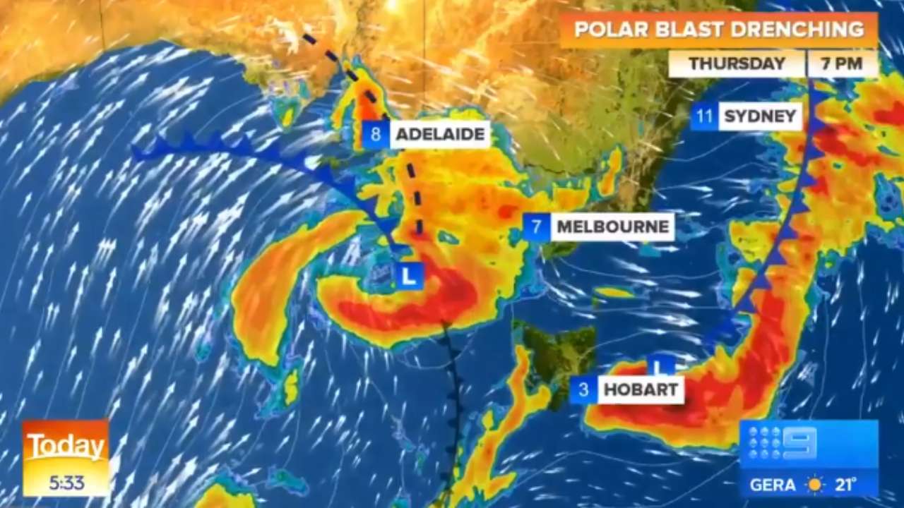
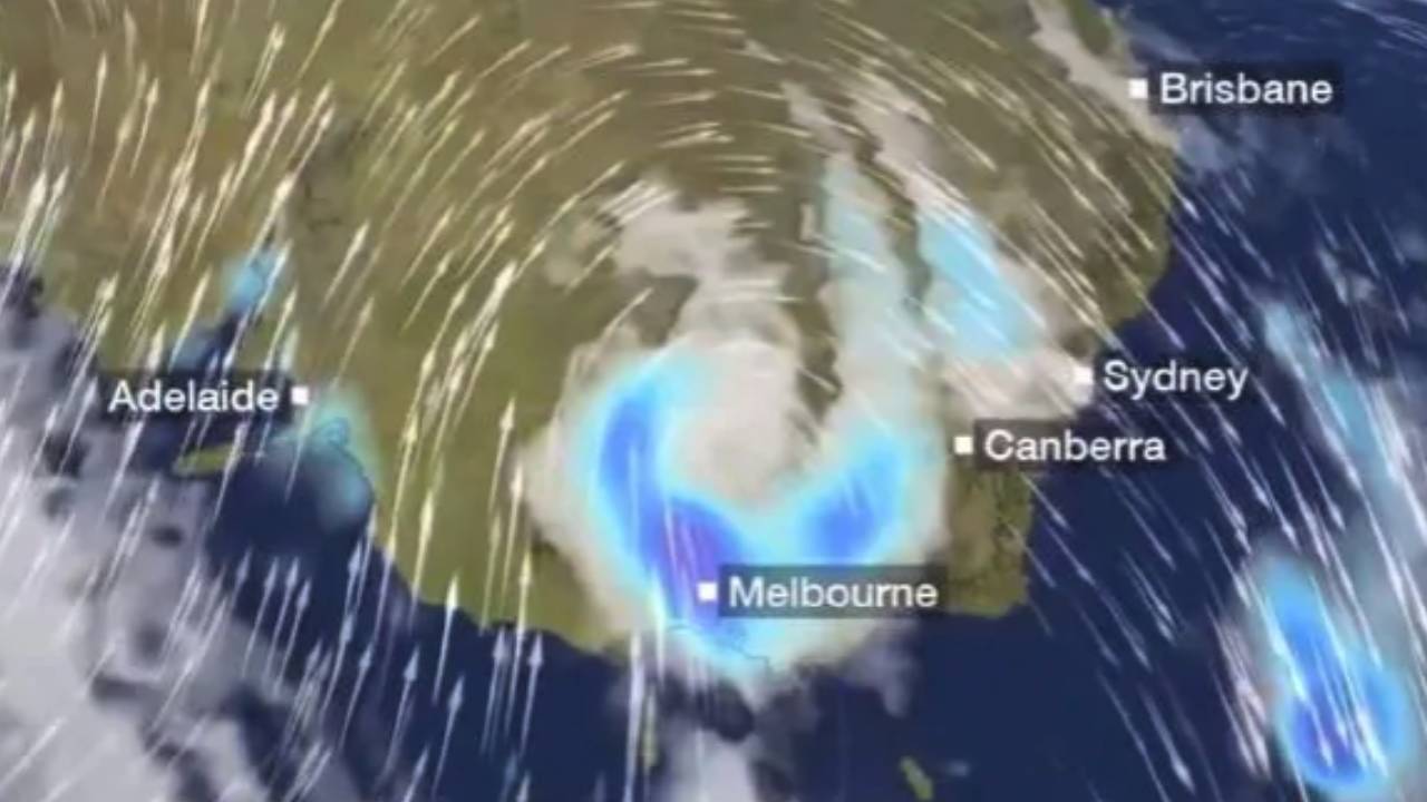
<p>With strong winds up to 130km/h, thunderstorms and hail set to hit Victoria due to a polar blast, the SES is urging people to act with extreme caution.</p>
<p>Melbourne’s south-east suburbs have been hit with winds up to 80km/h, with harsher winds expected over the weekend.</p>
<blockquote class="twitter-tweet" data-lang="en-gb">
<p dir="ltr">Victoria is bracing for strong winds, hail, and thunderstorms as a polar blast sweeps through the country's south east. <a href="https://twitter.com/hashtag/9Today?src=hash&ref_src=twsrc%5Etfw">#9Today</a> <a href="https://t.co/VwLtxE7DLg">pic.twitter.com/VwLtxE7DLg</a></p>
— The Today Show (@TheTodayShow) <a href="https://twitter.com/TheTodayShow/status/1159552003690729472?ref_src=twsrc%5Etfw">8 August 2019</a></blockquote>
<p>The SES has warned residents to be careful after a tree fell into a house at Frankston overnight.</p>
<p>"It's now the time to secure things around your home, whether it's trampolines or outdoor furniture and if you’re in a high-rise building, secure anything you have on your veranda," a spokesman told <a rel="noopener" href="https://www.9news.com.au/wild-weather/weather-forecast-victoria-to-be-hit-as-polar-blast-smashes-south-east-australia/ece22f0b-6190-4d65-a80c-1e2f6a5835df" target="_blank">9News</a>.</p>
<p>"More particularly we’re telling people to take particular caution while on the roads."</p>
<blockquote class="twitter-tweet" data-lang="en-gb">
<p dir="ltr">With an almighty roar, the entire roof has just blown away at work in Silvan <a href="https://twitter.com/hashtag/storms?src=hash&ref_src=twsrc%5Etfw">#storms</a> <a href="https://twitter.com/hashtag/polarblast?src=hash&ref_src=twsrc%5Etfw">#polarblast</a> <a href="https://twitter.com/vicemergency?ref_src=twsrc%5Etfw">@vicemergency</a> <a href="https://twitter.com/7NewsMelbourne?ref_src=twsrc%5Etfw">@7NewsMelbourne</a> <a href="https://twitter.com/9NewsMelb?ref_src=twsrc%5Etfw">@9NewsMelb</a> <a href="https://t.co/y1lIZRiNUQ">pic.twitter.com/y1lIZRiNUQ</a></p>
— Kristin (@Kristin542) <a href="https://twitter.com/Kristin542/status/1159604943713533953?ref_src=twsrc%5Etfw">8 August 2019</a></blockquote>
<p>A severe weather warning remains in place for southern parts of the South West and Central districts of Victoria, including the south-eastern suburbs of Melbourne, the Mornington Peninsula and the west Gippsland coast.</p>
<p>"Winds are expected to ease over western and central areas this morning – and over the east this afternoon – although there may still be some strong squalls with passing shower," explained the BoM.</p>
<blockquote class="twitter-tweet" data-lang="en-gb">
<p dir="ltr">The Severe Weather Warning has been updated with damaging winds currently being observed over the <a href="https://twitter.com/hashtag/SnowyMountains?src=hash&ref_src=twsrc%5Etfw">#SnowyMountains</a> and <a href="https://twitter.com/hashtag/Illawarra?src=hash&ref_src=twsrc%5Etfw">#Illawarra</a>. Gusty winds will continue to build over <a href="https://twitter.com/hashtag/Sydney?src=hash&ref_src=twsrc%5Etfw">#Sydney</a> and the <a href="https://twitter.com/hashtag/Hunter?src=hash&ref_src=twsrc%5Etfw">#Hunter</a> after mid-morning. <a href="https://t.co/Ss766eSCrL">https://t.co/Ss766eSCrL</a> <a href="https://t.co/Bp6ZL7P0h8">pic.twitter.com/Bp6ZL7P0h8</a></p>
— Bureau of Meteorology, New South Wales (@BOM_NSW) <a href="https://twitter.com/BOM_NSW/status/1159550153755385856?ref_src=twsrc%5Etfw">8 August 2019</a></blockquote>
<p>Weather warnings are also in place for NSW and the ACT as the cold blast is expected to move east. It’ll bring rain, thunder, hail and damaging winds along with it, with peak gusts expected to be more than 90km/h.</p>
<p>A severe weather warning is in place for the Southern Tablelands, Snowy Mountains, Illawarra, Southern Coastal Ranges, ACT, eastern parts of the Central Tablelands, the Sydney Metropolitan area, Hunter and parts of the northern ranges.</p>
<p>Blizzards are predicted for Alpine areas above 1500 metres, with the NSW National Parks and Wildlife Service recommending back country travelling be postponed until conditions improve.</p>
<p>For avid skiers, Perisher has seen more snowfalls overnight as the cold front continues to move over the resort.</p>
<blockquote style="background: #FFF; border: 0; border-radius: 3px; box-shadow: 0 0 1px 0 rgba(0,0,0,0.5),0 1px 10px 0 rgba(0,0,0,0.15); margin: 1px; max-width: 540px; min-width: 326px; padding: 0; width: calc(100% - 2px);" class="instagram-media" data-instgrm-captioned="" data-instgrm-permalink="https://www.instagram.com/p/B06sD33nfIR/" data-instgrm-version="12">
<div style="padding: 16px;">
<div style="display: flex; flex-direction: row; align-items: center;">
<div style="background-color: #f4f4f4; border-radius: 50%; flex-grow: 0; height: 40px; margin-right: 14px; width: 40px;"></div>
<div style="display: flex; flex-direction: column; flex-grow: 1; justify-content: center;">
<div style="background-color: #f4f4f4; border-radius: 4px; flex-grow: 0; height: 14px; margin-bottom: 6px; width: 100px;"></div>
<div style="background-color: #f4f4f4; border-radius: 4px; flex-grow: 0; height: 14px; width: 60px;"></div>
</div>
</div>
<div style="padding: 19% 0;"></div>
<div style="display: block; height: 50px; margin: 0 auto 12px; width: 50px;"></div>
<div style="padding-top: 8px;">
<div style="color: #3897f0; font-family: Arial,sans-serif; font-size: 14px; font-style: normal; font-weight: 550; line-height: 18px;">View this post on Instagram</div>
</div>
<p style="margin: 8px 0 0 0; padding: 0 4px;"><a style="color: #000; font-family: Arial,sans-serif; font-size: 14px; font-style: normal; font-weight: normal; line-height: 17px; text-decoration: none; word-wrap: break-word;" rel="noopener" href="https://www.instagram.com/p/B06sD33nfIR/" target="_blank">The heavy machinery is out for snow clearing this morning! 👷🏽♂️👷🏼♀️</a></p>
<p style="color: #c9c8cd; font-family: Arial,sans-serif; font-size: 14px; line-height: 17px; margin-bottom: 0; margin-top: 8px; overflow: hidden; padding: 8px 0 7px; text-align: center; text-overflow: ellipsis; white-space: nowrap;">A post shared by <a style="color: #c9c8cd; font-family: Arial,sans-serif; font-size: 14px; font-style: normal; font-weight: normal; line-height: 17px;" rel="noopener" href="https://www.instagram.com/perisher_resort/" target="_blank"> Perisher</a> (@perisher_resort) on Aug 8, 2019 at 2:01pm PDT</p>
</div>
</blockquote>
<p>Over half a metre of fresh snow has fallen at the ski resort, with more predicted over today and tomorrow.</p>